I can't believe I accidently erased everything I've done for the last two hours. Well, I'll try to piece it, together.
I am going to start, tonight, with my favorite picture of the day. This is between Chama NM and Antonito CO.

Nancy said it's very difficult to capture the scenery with her camera. Even with a good camera, a photo is like looking at a very small piece of a masterpiece. It's hard to relate the vastness in these mountains. She and Rich always loved the San Juans. Nancy once read that originally the Rocky National Park was supposed to be located in the southwest part of the state, but there was too much privately owned land.
Starting out on our journey, we came across this sign. It has so many bullet holes in it, it can't be read. What a shame.

We wanted to go to Antonito to see where the end of the Cumbres & Toltec ended. We had a great ride. We discovered that we are only 7 miles to the border of Colorado. We went over passes that were over 10K high. The day was beautiful, but it was prudent to be cautious when coming down off the passes--wind.

Along the way we passed by outfitters, tackle shops, and what looked like cabins that could rented along with permanent homes. beautiful streams and glorious colors as spring begins in the rockies.
Cabins

Outfitters

Streams that Feed the River


Ranch

We passed a little town called
Magote on the way, and another community (no stores except a tackle shop) called Fox Creek.


Boy, I'm getting tired and Nancy's already asleep. I'll keep going, though. Here's a church that has seen better days.

The Cumbres & Toltec takes a full day to get to Antonito and return to Chama. The road follows it for a time, but then it goes off into the mountains.
Antonito RR Yard

Water Tower RR Yard

We saw elk, but we weren’t in a place where we could stop to get a picture. I was surprised at how many trail heads were along the route. One was Duck Trail, Something Hole, and Red Something (those are only the ones we saw). I imagine they are for seasoned hikers—lots of room out there to get lost.
Along the route of the train we saw some little houses. My sense was that they served as shelter during bad weather, but I could be wrong. Nancy nor I saw any signs stating what they were--the winter weather knocks down some of the signs.
 We passed a number of private RV parks along with the state and national campgrounds. This is one I would have liked to have stayed in. Nancy said if the other gals were still with us, we could have chosen one of the national parks where they could hike and fish.
 When we got to Antonito, Nancy gave me water and took me for a walk through town. Following are the pictures of Antonito. It was a small town, but it had a small park, and of course the main attraction was the Cumbres and Toltec.


 Well, that was our day of travel. When we got back to camp, Nancy took me for a walk and then played ball with me. I just knew she had a ball hidden in her pocket. She said I musn't bark because then the owners would discover I am off leash. We go way down to a vacant part of the park where we don't think anyone will notice us. I'm going to sleep, now. I'm very tired, especially after losing all this the first time.
(We discovered after we were home that there was a fire on the bridge just north of the campground, and the train couldn't run. It happened not longer after we left the area.
History and Fire )


RR Yard


Right where the town park was, there were water towers which displayed some great folk art.


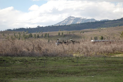
On the way home, by chance we caught the train returning to Chama.


(We discovered after we were home that there was a fire on the bridge just north of the campground, and the train couldn't run. It happened not longer after we left the area.
History and Fire )
No comments:
Post a Comment
Thank you for visiting. Have a great day.